The Museum of Perth chronicles the social, cultural, political and architectural history of Perth.
The Causeway
Linking Perth's eastern suburbs to the city, the Causeway bridge has undergone several changes as it quickly became one of Perth's most crucial pieces of infrastructure.

Looking west over the Causeway towards Perth, 1989 (Supplied: State Library of Western Australia)
Ever since the establishment of the Swan River Colony, bridging the river to connect Perth's east and west has been a necessity. With the concept of the Causeway dating back to 1830, the bridge itself is a hugely important historical structure for our city, and one that requires constant development in order to provide quick and free-flowing access to the CBD.

Between 1837 and 1838, preliminary works were completed before construction fully began; these included paving Adelaide Terrace up to the riverfront. The first Causeway commenced construction on 2 November 1840 with pile driving for the foundations taking place. The bridge itself was completed a year later in 1841 with the surrounding approaches being finished throughout 1842. The Causeway was officially opened by Chairman of the Road Trust J. W. Hardey on 24 May 1843.
The bridge was originally a toll road with 6d being charged to horse and carriage riders, and 1d for pedestrians on foot to cross. The original Causeway remained the only Swan River crossing in Perth for 19 years until it was largely destroyed during flooding in the winter of 1862. Pictured above, the first Causeway in 1862, prior to its destruction later that same year. (Supplied: State Library of Western Australia)

The second Causeway was built in response to the flooding which had occurred in June 1862. Designed by colonial architect Richard Roach Jewell, the Causeway was reconstructed several feet higher than the original, using convict labor. It was officially opened, along with the Guildford and Helena bridges the same day, by WA Governor John Stephen Hampton on 12 November 1867. The Causeway was originally to be opened by HRH Prince Albert, Duke of Edinburgh in a grand affair but due to the Duke's royal yacht failing to dock at Fremantle harbor, the Governor took his place in the proceedings.
Consisting of three bridges totaling 490 metres, the second Causeway was structurally weak for its time due to budget constraints and required numerous upgrades throughout the years. The bridges were strengthened and their width increased on three separate occasions in 1899, 1904, and 1932 respectively, culminating in a total width of 11 metres. The second Causeway stood proud for 80 years until it was replaced by the current dual Causeway bridges that connect Perth to Victoria Park via Heirisson Island in 1947. Pictured above, the second Causeway bridge looking east to Victoria Park, 1905. (Supplied: State Library of Western Australia)

"The diagram shows the Government's proposal for widening the Causeway from 17ft to 27ft for vehicular traffic. The present footway will be removed and the space used for the roadway, and a new footway will be built on the existing pipe trestles, which run parallel with the causeway." -The West Australian, 23 August 1932.

Traffic over the Causeway had doubled between 1931-1939, prompting calls for a new, larger bridge to be constructed on the site. Due to the outbreak of the Second World War, both construction of the Narrows Bridge, and the Causeway were delayed until the mid 1940s when development began for the third iteration of the Causeway bridges in 1947. Designed by E. W. C. Godfrey, they were only the second bridges in Australia to use steel composite construction, and required significant dredging to widen navigation channels either side of Heirisson Island, which was converted from two separate islands into the singular one we know today.
The bridges have a combined length of 341 metres and stand 19 metres wide. Because of steel and concrete shortages due to the war, the piles for the support columns were made of jarrah timber, not concrete, and the design avoided the use of costly steel plate girders wherever possible. The concrete used on the superstructure was sourced from seven different locations, meaning the Causeway has differing durability at certain points along each bridge. Pictured above, the current Causeway under construction, 1951. (Supplied: State Library of Western Australia)

Due to the increasing congestion of traffic crossing the river each day, large roundabouts were built at both the eastern (in 1952) and western (in 1954) side of the Causeway to enable faster movements when entering and exiting the roadway.
The construction of the Narrows bridge in 1959 helped ease traffic problem facing the Causeway as it enabled a secondary route into Perth from the south-eastern suburbs.
In 1973, the eastern roundabout was removed and replaced with a partial cloverleaf interchange to enable vehicles travelling north-south to traverse over the roadway without having to enter the stream of traffic heading east-west.
The bridges were designed to handle tramcars as the second iteration of the Causeway had operated electric tramcars for several decades prior but, due to public opinion, tram lines have not been installed as their overhead wires were considered ugly at the time.
In 2000, the opening of the Windan Bridge of the Graham Farmer Freeway had a significant effect on the daily amount of cars travelling across the Causeway. This enabled two of the bridges six lanes to be converted to dedicated bus lanes to enable a quicker public transport connection between the CBD and the Victoria Park Transfer Station.
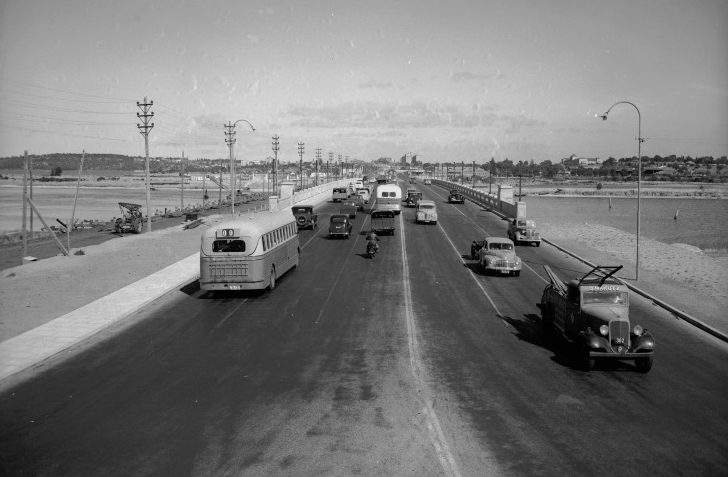
The third iteration of the Causeway shortly after construction, 1955. (Supplied: State Library of Western Australia)

The third Causeway under construction in 1951, with the second causeway still standing to the left. Clearly visible, the eastern roundabout is taking shape but the western won't be built for another two years. (Supplied: National Library of Australia)

North side of the Original Causeway, 1865. (Supplied: State Library of Western Australia)
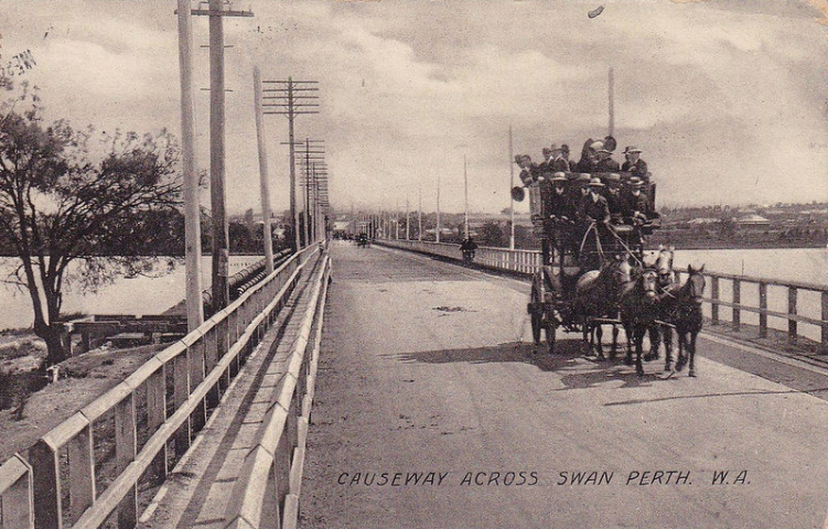
"Causeway Across Swan Perth WA", 1905 (Supplied: flickr)

The Causeway, 2005. (Supplied: Wikimedia Commons)